|
COOLEY'S CORNERS
The lost village of Cooley's Corners was located at the intersection of 24 Mile and Schoenherr Roads. Cooley's Corners
was the home of Dr. Dennis Cooley. He was a botanist who wrote several papers on the area's plant life during the late 1880's.
In addition to being a medical doctor, Dr. Cooley served as the Washington Postmaster from 1836 to 1859.
PRESTONVILLE
The lost village of Prestonville was located at the junction of 25 Mile and Schoenherr Roads. This small interrelated
community was started by John Tupper and Ira Preston. Preston purchased five 80-acre land parcels from the United States Government
in 1826. These were located on the middle branch of the Clinton River. The families in groups of twenty individuals came from
New York in 1827. They brought with them the parts necessary for the construction of a small sawmill. The sawmill was the
first in Macomb County. It operated for forty years and disappeared in the 1870's.
The Preston family built an 18 by 24 foot, shake roof, log cabin with bark-covered gable ends, a blanket for a door, and
a floor made of split logs. Ice was obtained from the mill pond, Cusick Lake, or even as far away as Lake St.Clair.
The Preston and Carleton family reunions were always big affairs. They included movies and an all family member girl band.
Today, there are still a few reminders of Prestonville's past. A chicken coop, which is slated for demolition when the
township builds a new fire station on the site in 2018, stands on the original Ira Preston farmstead. A small building located
near the chicken coop is the first timber frame house Ira Preston built for his family. Plans are currently underway to restore
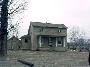
this building. And just to the west on 25 Mile Road stands the Ira Luman Preston house, built in 1856.
Ira Preston, in 1838, deeded a one-acre parcel of his land for the establishment of the Prestonville Cemetery, which can
be found on 25 Mile Road west of Schoenherr. The majority of the Preston and Carleton family members are buried in the Prestonville
Cemetery.
Prior to the construction of a one-room schoolhouse on Preston land in Prestonville (later identified as Shelby School
#3) residents had to travel to neighborhood villages for school: 1)grades 1-8 to Macomb Corners; 2) grade 9-10 to Davis. The
Normal Teachers School offered a one year course and was located in New Baltimore. Travel required the utilization of wagon
cart to Chesterfield Township and then boarding the Interurban to New Baltimore.
In 1881, the Prestonville school enrollment consisted of 64 students. A teacher was paid $500 a year for his or her services.
During the 1920's seventh grade students were required to travel to Utica for testing prior to qualification of passage to
8th grade. They also had to return prior to passage to the 10th grade. The school closed in 1954 and the building was demolished
in 2003.
DEPEW/DEPEW SIDING
Depew/Depew Siding was a train stop at 23 mile Road, 1/2 mile east of Dequindre. This was a milk stop, located on the
property owned by the Depew's around 1895. The area later became the G&H Land Fill.
SHELBY STATION/SHELBY CROSSING
The junction of the Michigan Air Line (later the Grand Trunk) Railroad tracks at 25 mile and Shelby Road was known as
Shelby Station or Shelby Crossing. Today the only recognition of any old settlement is the Curtis Cemetery. The older structures
in the area are long gone. These included a house and barn on the southwest corner. The barn burned down in the mid 1960's.
A turkey farm with a house and barn also stood on the northwest corner. (The Historical Committee has a picture of it on file.)
Besides being utilized as a milk stop, local residents could board the train for travel to Rochester MI. Local residents
were often warned to watch out for hobos who frequented the train. Mr. Dull, who lived on the southwest corner, rode his handcart
up the right of way to Washington where he worked for Western Union.
On October 28, 1881, 200 local citizens chased a bear for 3 miles and found it accompanying two "tame" Indians.
The Curtis Cemetery contains sites of many former area residents including: Hiram Andrews, The Curtis's, Issac and Mary
Monfort, and veterans of the Mexican War (1848) and of the Civil War.
SOURCES: Lost Villages, Small Towns and Railroad stops in Oakland and Macomb County by Deborah J. Remer
(Sponsored by Rochester Hills Museum and Van Hoosen Farm)
|
