These aren't your grandfather's Macomb County roadways.
Over time, as Southeast Michigan and Macomb County have grown and evolved,
the way residents have moved around the area has changed dramatically.
It was once the birch bark canoe and steamboat, then horse, train and Detroit
Interurban.
Finally, at the tail end of the 19th Century, a new-fangled contraption took
to the trails and streets of the area: the "horseless carriage."
The automobile would change forever the way that the people of Michigan and
the world would get around. Getting there would be half the fun ... in more ways than one.
In the beginning
"The original roads were based on trails created by the Indians," said Edwin
Tatem, Highway Engineer for the Road Commission of Macomb County.
When French settlers arrived in Southeast Michigan in the late 17th and early
18th centuries, they developed and combined the narrow American Indian trails with a series of spiraling road paths. British
influence changed some aspects of the road system when they took over control of the area.
"They laid out a quasi-grid pattern that went from Detroit all the way into
Macomb County," Tatem said. Following the War of 1812, "roads" were formed to connect the forts in Michigan.
When the Michigan Territory was surveyed in the 1820s and 1830s, baseline
and meridian demarcations as well as town and range lines helped establish the section lines and boundaries of modern townships.
The system allowed the natural implementation of mile roads and other travel
ways along the designated boundaries of the section lines.There were pre-established routes that continued to evolve.
"Principal highways were radiating from downtown Detroit and from counties
all the way through the state," Tatem said. "Certain trails that were predominantly Indian trails were further developed.
For example, Gratiot was a trail from Detroit to Port Huron while Woodward ran from Detroit to Pontiac. Grand River went to
Grand Rapids."
One section of major southern Michigan roadway retains a name-link to its
heritage. U.S. 12 to Chicago, is known not only as Michigan Avenue, but as the Sauk Trail.
Rough roads ahead
As roads developed in the state, support began to grow for some form of organized
road construction, similar to the desires of motorists today.
Early roads were rough, uneven and were often no more than a crude path blazed
through the woods over stumps and through swamps.
But they allowed settlers to travel into the state's interior and farmers
could transport their crops and livestock to market.
"Highway development in the county itself like the mile roads, formed under
a territorial administration," Tatem said. "Later on, there were plank roads where they put planks down to have roads so carriages
could travel. They were supposed to be 16 feet wide and be a smooth, permanent road."
Again, a local Macomb County road carries a hint of its heritage: Romeo Plank.
Another major road, the Detroit to Pontiac plank road, opened in 1849.
A labor system and tax structure evolved to implement road construction and
maintenance."People who lived along the roads could pay the tax or they could actually do physical labor on the road themselves,"
Tatem said.
Into the 20th Century and with the invention and continued evolution of the
automobile, the state highway department was created to handle major infrastructure roads in Macomb and across the state.
"They also were dealing with state trunk line roads. County road commissions
then developed to handle the local roads within their jurisdictions.
While many streets were brick or concrete within cities, routes outside the
urban areas were still no more than muddy two-tracks, making automobile travel more of an adventure than a routine commute.
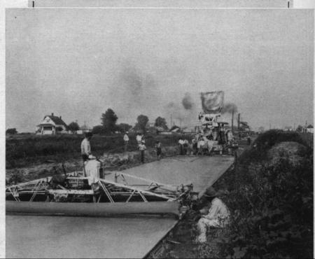
In the metro-Detroit area, the first mile of rural concrete highway in the
world was built in 1909 on Woodward between Six Mile and Seven Mile roads in Detroit. More paving would follow.
"In the Depression era, there was not much work for road projects. Then around
World War II, around the area they began improving the infrastructure to move war materiel. They started to get more money
for construction because of legislation that gave them federal funding to protect the country for military purposes."
As a result of that war spending, the first freeway in Southeast Michigan
was constructed. "The Davison Freeway, a mile road between Woodward all the way over to what we know today as I-75, was built
in 1942 in front of Chrysler because they were building tanks," Tatem said.
After World War II, Act 51 in 1951 set up the road system we have today.
"It applied to all the roads in the state today," he said. "The motor vehicle
highway fund was established and we are able to fund a lot of the projects we have in terms of the freeway system and the
road system that we have today. They were able to build the mile roads, Gratiot and M-53.
A view from behind the wheel
Looking around the streets of Macomb County and Shelby Township, Clendon "Dick"
Mason can see a lot has changed since the days when he first joined the Shelby Township Police Department as a part-time officer
in 1956.
"Most of the roads were gravel and Van Dyke was two lanes all the way down
into Warren," he said. "If someone stopped and wanted to make a left hand turn, you'd be late for work."
Mason said that all the mile roads in Shelby Township were gravel."Hayes between
Hall Road and 21 Mile I remember as being a two-track," he said.
Most intersections were governed by stop signs, but I believe there was a
traffic light at 23 Mile Road and Van Dyke, but it only worked five days a week and it went to a blinker after 6 p.m. and
on the weekends.
Traffic, he said, was similar in some respects to that of today."There were
fewer cars, but there were also fewer roads," he said. "If you wanted to go from point A to point B on a Friday night, you
had to fight traffic."
Mason said that in some areas of the state, there were no speed limits. "That
wasn't so much in the county, but throughout the state," he said.
Growth, by leaps and bounds
The township was sparsely populated north of 24 Mile Road or east of Van Dyke.
There would often be large lapses in time between cars traveling down the roads.
"In the late '50s - I think it was '58 or '59, the Free Press delivery man
broke down on 24 Mile Road around 2 a.m.," Mason said. "I was the first person to go by there a little after 8 a.m. to see
him."
For the first 40 years of the 20th century, Shelby and Sterling townships
boasted farms as far as the eye could see.
Following World War II, however, the farms of the area began to give way to
subdivisions as the area experienced a growth spurt. City dwellers from Detroit began making a migration to the north along
the major traffic corridors of Van Dyke and Gratiot to develop the northern suburbs.
In the 1950s and '60s, Warren was developed, a trend that carried into Sterling
Township -today's Sterling Heights -- in the 1960s and '70s.
It was Shelby Township's turn in the 1980s and 1990s and the trend continues
north into southern Washington Township.
By 1975, traffic had reached a point where township officials and police administration
realized that more police were needed to handle the township roadways.
Fourteen officers were hired to staff the township's new Traffic Enforcement
Bureau.
Today, with all the growth in middle and northern Macomb County, traffic volumes
during the morning, lunchtime and afternoon commutes can easily reduce a short drive to an exercise in hair-pulling gridlock.
Mason said that vehicles and people's driving habits also add to the degree
of difficulty."As an example, there is a lot more red-light running today," Mason said. "When the light turns green, you have
to wait so the people who are going to run the light can go through the intersection. I think back then, drivers were a little
more cautious and they drove at slower speeds than they do today."
Those congested roads and the drivers that travel them can combine with other
factors to create a combination that can, at one extreme, be a nuisance or the other, a deadly combination.
JON OTTMAN SOURCE NEWSPAPER 10-31-03